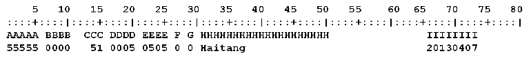
The dataset includes the CMA historical (since 1985) satellite estimates for tropical cyclone intensity, which are based on the Dvorak technique. These satellite estimates were one of the data sources used to develop the Best Track Dataset. The relationship between the current intensity (CI) number and tropical cyclone maximum sustained wind speed (MSW) is as follows:
Digitization of the entire dataset is not yet complete; the currently available data cover the period 2008–2012.
|
CI
|
MSW (m/s)
|
|
|---|---|---|
|
1985-1993
|
1994-
|
|
|
1.5
|
13
|
13
|
|
2
|
15
|
15
|
|
2.5
|
18
|
18
|
|
3
|
20
|
23
|
|
3.5
|
28
|
28
|
|
4
|
30
|
33
|
|
4.5
|
39
|
39
|
|
5
|
43
|
46
|
|
5.5
|
52
|
52
|
|
6
|
56
|
59
|
|
6.5
|
65
|
65
|
|
7
|
72
|
72
|
|
7.5
|
79
|
79
|
|
8
|
87
|
87
|
Updates and downloads:
Recently updated: Nov., 2020
Since Nov., 2020, the total number of downloads:
Please indicate that the CMA Satellite Analysis Dataset for Tropical Cyclones over the Western North Pacific was obtained from tcdata.typhoon.org.cn, and refer to the following paper in any written work using the dataset:
- Ying, M., W. Zhang, H. Yu, X. Lu, J. Feng, Y. Fan, Y. Zhu, and D. Chen, 2014: An overview of the China Meteorological Administration tropical cyclone database. J. Atmos. Oceanic Technol., 31, 287-301. doi: 10.1175/JTECH-D-12-00119.1
CHYYYYBST.txt ——
CH: First label of the dataset, denotes CHINA.
YYYY: Four-digit calendar year.
BST: Second label of the dataset, denotes SATELLITE ANALYSIS data.
1. Header record
| AAAAA | 5 columns | Header line indicator, '55555' indicates satellite analysis data. |
| BBBB | 4 columns | International ID. |
| CCC | 3 columns | Number of data lines. |
| DDDD | 4 columns | Tropical cyclone serial number. |
| EEEE | 4 columns | Chinese ID. |
| F | 1 column | Flag of the last data line, now F = 0. |
| G | 1 column | Time interval, now G = 0. |
| H...H | 20 columns | Storm names, ‘(-)n’ denotes sub-center and its number. The sub-center refers to a center that was split or induced from the original tropical cyclone circulation center. |
| I...I | 8 columns | Date of the latest revision.. |
2. Satellite analysis data record
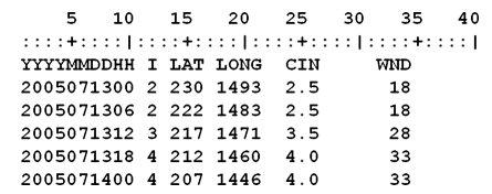
| YYYYMMDDHH: | Date and time in UTC: 4-digit year, 2-digit month, 2-digit day, and 2-digit hour |
| I: |
Intensity category according to the Chinese National
Standard for Grade of Tropical Cyclones (which has been
used since 15 June 2006): 0 –– Weaker than Tropical Depression or unknown intensity; 1 –– Tropical Depression (TD: 10.8–17.1 m/s); 2 –– Tropical Storm (TS: 17.2–24.4 m/s); 3 –– Severe Tropical Storm (STS: 24.5–32.6 m/s); 4 –– Typhoon (TY: 32.7–41.4 m/s); 5 –– Severe Typhoon (STY: 41.5–50.9 m/s); 6 –– Super Typhoon (SuperTY: ≥51.0 m/s); 9 –– Extratropical Cyclone (ET) stage. |
| LAT: | Latitude(0.1°N); |
| LONG: | Longitude (0.1°E); |
| CIN: | Current intensity (CI) number. |
| WND: |
Two-minute mean maximum sustained wind (MSW; m/s) near the
TC center. WND = 9 indicates MSW < 10 m/s, WND = 0 indicates unknown intensity. |
- This website provides tropical cyclone related data in accordance with the relevant laws and regulations of the People’s Republic of China and meteorological data sharing provisions. The data of this website is for research reference only and shall not be used for commercial purposes. China Meteorological Administration, Shanghai Typhoon Institute and the website are not responsible for any loss caused by the use (or inability to use) of the data of this website.